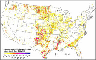
Atlas pinpoints abandoned croplands for potential biofuel production

Background/Objective
To identify and map abandoned croplands available for bioenergy production within the coterminous United States (CONUS) between 1986 and 2018.
Approach
Researchers used existing land cover data sets to train a computer algorithm to classify land use patterns in satellite imagery. These classifiers were then used to map cropland annually from 1986 to 2018 at a 30-meter resolution. Researchers then identified the location and time of abandonment using a moving temporal window for each pixel and estimated the accuracy against visually interpreted sample locations and publicly available datasets.
Results
From 1986 to 2018, 12.3 million hectares of croplands were abandoned across CONUS, with areas of greatest change over the Ogallala Aquifer, the Northern Great Plains, and the Mississippi Alluvial Valley.
Annual abandonment peaked between 1997 and 1999. Among abandoned croplands, 53% changed to grassland and pasture, 18.6% to shrubland and forest, 8.4% to wetlands, and 4.6% to non-vegetated lands. Only 19.6% were enrolled in the Conservation Reserve Program as of 2020.
Impact
Abandoned croplands are considered potential sites for land-based climate mitigation strategies, including the production of bioenergy feedstocks. These spatially-explicit maps can help researchers gain a better understanding of the potential production and other benefits of using these lands for bioenergy.
Yanhua Xie, et al, Cropland abandonment between 1986 and 2018 across the United States: spatiotemporal patterns and current land uses, Environmental Research Letters, 19, 044009 (2024). [DOI:10.1088/1748-9326/ad2d12]